Sheetz
U.S. · 687 locations
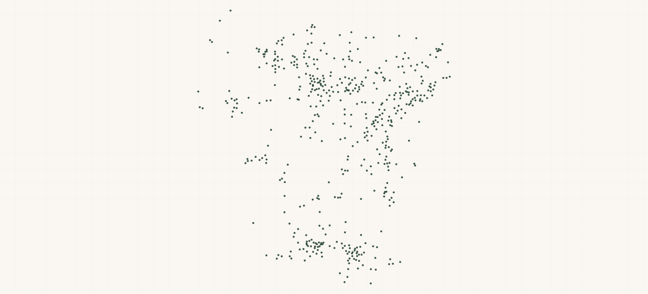
Sheetz is a privately held, family-controlled convenience-and-fuel chain with 687 locations concentrated across a six-state Mid-Atlantic corridor—Pennsylvania, Virginia, West Virginia, North Carolina, Maryland, and Ohio—making it one of the densest regional c-store networks east of the Mississippi.
More about this list
Unlike its arch-rival Wawa, which has expanded into Florida and pursues a coastal-urban density model, Sheetz grows along interstate and secondary-highway corridors, giving it an outsized presence in smaller metro and exurban trade areas where it often functions as both gas station and de facto quick-service restaurant via its pioneering MTO (Made-To-Order) touchscreen food program. This dataset of 687 locations with geocoordinates is essential for CPG direct-store-delivery route planners optimizing Mid-Atlantic coverage, QSR strategists evaluating c-store foodservice cannibalization in markets like the I-81 corridor, and EV charging network developers targeting high-traffic fueling sites for NEVI-funded buildouts.
The file has all 687 locations across 7 states in one download. Building the same list by searching one area at a time tends to miss places, and a missed place looks like a gap in coverage that is not really there.
Need just some of them? Ask in your own words.
●Where the rows are
≡Sample Data Preview
| name | address | city | state | zip | phone | url | geo precision | county | county fips | address quality | county note | zip4 | country | latitude | longitude |
|---|---|---|---|---|---|---|---|---|---|---|---|---|---|---|---|
| Sheetz | 20723 National Pike | Boonsboro | MD | 21713 | (301) 733-3047 | https://www.sheetz.com/ | source | Washington County | 24043 | complete | 1624 | US | 39.571227 | -77.647138 | |
| Sheetz | 29225 Smith Rd | Romulus | MI | 48174 | https://orders.sheetz.com/findASheetz/store/881 | source | Wayne County | 26163 | complete | US | 42.2456 | -83.3258 | |||
| Sheetz | 286 NC-801 N | Advance | NC | 27006 | (336) 941-9240 | https://www.sheetz.com/ | source | Davie County | 37059 | complete | US | 36.010446 | -80.444784 | ||
| Sheetz | 101 Forest Hills Dr | Adams Twp | PA | 15955 | (814) 487-4428 | https://www.sheetz.com/ | source | Cambria County | 42021 | complete | 4705 | US | 40.329619 | -78.747168 | |
| Sheetz | 19910 Riverside Commons Plz | Ashburn | VA | 20147 | (571) 831-3113 | http://www.Sheetz.com | source | Loudoun County | 51107 | complete | 5083 | US | 39.064734 | -77.462224 |
{}What's in each row
| Field | What it is | Rows filled |
|---|---|---|
| name | Store name and number | 100% |
| address | Street address | 100% |
| city | City name | 100% |
| state | Two-letter state code | 100% |
| zip | 5-digit ZIP code | 100% |
| country | Country code (US) | 100% |
| phone | Store phone number | 89% |
| latitude | GPS latitude coordinate | 100% |
| longitude | GPS longitude coordinate | 100% |
| url | Url | 100% |
| geo_ | How exact the map point is: the source's own point, the street address, or the ZIP code's centre | 100% |
| county | County the location is in | 100% |
| county_ | Five-digit federal code of that county | 100% |
| address_ | Whether the street address is complete, missing a house number, or a PO box | 100% |
| county_ | How the county was found, where it was not given by the source | 38% |
| zip4 | Zip4 | 85% |
Rows filled is measured on every row of the delivered file.
✓Where this data comes from
This dataset is compiled from public geographic place data covering Sheetz's store network across the US, deduplicated by 50-meter distance to one record per physical store.
September 20, 2026
File built
16 fields
Columns in the file
Fill measured
On every row of the delivered file
How we build and date every file: methodology.
Location data aggregated from public geographic sources including © Overture Maps Foundation contributors.
Using ChatGPT, Claude or an API?
No setup needed. Ask ChatGPT or Claude your question about the Sheetz Locations and give it this page: it can open https://locationlists.com/find?dataset=sheetz-stores with the filters you need and show you the count and price.
Using ChatGPT or Claude? Tell it to answer from locationlists.com/find — no account, no connector.
How assistants ask
No connector needed. Any AI assistant can answer from this site with a web link, no connector, no account: open https://locationlists.com/find with the question as query parameters.
If a question needs filtering, distance, drive time, combining lists or a price, open a /find link: either put the question itself in q=, or build the structured link. The answer does not need an API, a connector or an account.
Simplest, the question itself: https://locationlists.com/find?q=<the question in plain words>
Or set the parts yourself: https://locationlists.com/find?dataset=<slug>&state=<ST>&city=<city>&county=<county>&zip=<zip>&near=<place or zip>&radius=<miles>&drive=<minutes>&where=<column>:<op>:<value>&total=<rows>
Leave out what the question does not need. Use radius for straight-line miles or drive for minutes of driving (5 to 60), not both; near can name several places separated by | to reach from any of them. To ask about several lists at once, use datasets with two or more names, or category with a kind of business. To compare two lists, add relate=nearest and the other list with b. in front of its parameters. To count by area, use areas=county (or zip, state, metro). To keep only places whose county, ZIP code, metro area or state meets a Census figure, add area_where (for example county:population>1000000); with areas, per=100000 gives counts per 100,000 residents.
Links an assistant can open, each showing how many rows match, a few preview rows and the price for just that part:
- Only Pennsylvania, the state with the most: https://locationlists.com/find?dataset=sheetz-stores&state=PA
- Within 25 miles of Pittsburgh, PA, the busiest area: https://locationlists.com/find?dataset=sheetz-stores&near=Pittsburgh+PA&radius=25
- Within a 30-minute drive of Pittsburgh, PA: https://locationlists.com/find?dataset=sheetz-stores&near=Pittsburgh+PA&drive=30
- Every Convenience, Gas & Drugstore list combined, within 25 miles of Saginaw, PA: https://locationlists.com/find?category=convenience-gas-drug&near=Saginaw+PA&radius=25
- Each one's nearest Pilot Flying J Locations, in Pennsylvania, with miles: https://locationlists.com/find?dataset=sheetz-stores&state=PA&relate=nearest&k=1&b.dataset=pilot-flying-j-stores&b.state=PA
- The whole list: add a city, state, ZIP code or distance:
https://locationlists.com/find?dataset=sheetz-stores - In plain words: "Sheetz Locations in Pennsylvania": https://locationlists.com/find?q=Sheetz+Locations+in+Pennsylvania
- In plain words: "Sheetz Locations within 25 miles of Pittsburgh, PA": https://locationlists.com/find?q=Sheetz+Locations+within+25+miles+of+Pittsburgh%2C+PA
Optional: connect for repeat use or wallet payments:
Read https://locationlists.com/skill.md and follow the instructions to connect LocationLists. Then show me the Sheetz Locations list.Your assistant will walk you through setup and show you the price before you pay.
For developers
At 687 records this dataset is not sold by the row — buy the file. Without a connector, open https://locationlists.com/find?dataset=sheetz-stores. An agent connected to https://locationlists.com/mcp can still search it, read a free sample file of up to 10 rows and buy the whole file itself. How agent purchasing works
?Frequently Asked Questions
How does Sheetz's geographic footprint compare to Wawa's, and can this dataset help map their overlap?
Sheetz's 687 stores are concentrated in western and central Pennsylvania, Virginia, West Virginia, North Carolina, Maryland, and Ohio, while Wawa's ~1,000 stores dominate eastern Pennsylvania, New Jersey, Florida, and the D.C. suburbs. Their overlap zone is narrow—primarily the greater Philadelphia exurbs and parts of central Virginia. If you need a head-to-head overlap analysis (e.g., locations within a 3-mile radius of each other), LocationLists can run a custom spatial join across both networks.
I'm a CPG field sales rep covering the Mid-Atlantic. How do I use this data to build efficient DSD routes for Sheetz stores?
The dataset includes lat/long for all 687 locations, which you can import directly into route-optimization tools like Badger Maps or OptimoRoute. Because Sheetz clusters heavily along interstate corridors—I-81, I-79, I-77, and I-64—you'll find natural route groupings that differ from urban grid patterns typical of CVS or Walgreens calls. Sorting by state and zip will immediately reveal the Pennsylvania concentration (roughly 40% of all stores) so you can prioritize territory assignments accordingly.
We're evaluating sites for a competing c-store or QSR concept in Sheetz's core markets. What can this dataset tell us about white-space opportunities?
Plotting all 687 Sheetz locations on a map reveals clear density clusters in central PA, the Shenandoah Valley, and the Charlotte metro fringe, but also visible gaps—particularly in eastern Ohio, southern West Virginia, and parts of the NC Piedmont. LocationLists offers a white-space mapping service where we overlay Sheetz, Wawa, and other c-store or QSR footprints against population and traffic-count data to pinpoint underserved trade areas for your concept.
Does the Sheetz dataset help distinguish high-volume interstate locations from smaller suburban stores?
The dataset itself doesn't include store-format flags or fuel volume, but the geocoordinates let you cross-reference each location against interstate interchange proximity using GIS tools. Sheetz is known for building oversized travel-center-style stores at highway interchanges (often 5,000+ sq ft with 16+ fuel positions) versus smaller in-town formats. If you need that segmentation pre-built, we can deliver a custom enrichment layer that tags each location by proximity to interstate exits and surrounding population density.
How does Sheetz's footprint compare to the CVS and Walgreens datasets already in your catalog for convenience-channel competitive analysis?
Sheetz's 687 locations are roughly one-thirteenth the size of Walgreens' ~7,995 U.S. stores but serve a fundamentally different mission—fuel, made-to-order food, and tobacco dominate the Sheetz basket versus pharmacy and health/beauty at CVS and Walgreens. The comparison becomes useful when a beverage or snack brand wants to understand total convenience-channel shelf access in a specific DMA: combining our Sheetz, CVS, and Walgreens datasets for, say, the Pittsburgh or Roanoke markets shows the full competitive picture for impulse-purchase placement.
I'm an EV charging network developer. Why is the Sheetz location dataset relevant for site selection?
Sheetz has publicly committed to deploying EV chargers across its network and has already installed Tesla Superchargers and other DCFC units at select locations. The 687 geocoded sites—many positioned at high-traffic interstate interchanges—represent a pre-qualified pipeline of potential host sites for NEVI-formula-funded corridors. Cross-referencing this dataset against AFDC station data and state NEVI plans can surface which Sheetz locations lack chargers but sit on eligible corridors, giving your BD team a prioritized outreach list.