Raising Cane's
U.S. · 973 locations
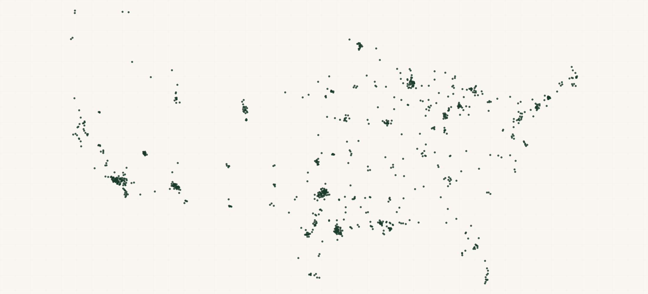
Raising Cane's operates 973 locations across the United States.
More about this list
This dataset provides the complete list of Raising Cane's store locations with verified addresses, phone numbers, and GPS coordinates sourced from official Raising Cane's systems.
The file has all 973 locations across 45 states in one download. Building the same list by searching one area at a time tends to miss places, and a missed place looks like a gap in coverage that is not really there.
Need just some of them? Ask in your own words.
●Where the rows are
≡Sample Data Preview
| name | address | city | state | zip | phone | url | geo precision | county | county fips | address quality | country | latitude | longitude |
|---|---|---|---|---|---|---|---|---|---|---|---|---|---|
| Raising Cane's Chicken Fingers | 849 East Dimond Blvd | Anchorage | AK | 99515 | (907) 865-3937 | https://locations.raisingcanes.com/ak/anchorage/849-east-dimond-blvd | source | Anchorage Municipality | 02020 | complete | US | 61.1449974593979 | -149.86630246946063 |
| Raising Cane's Chicken Fingers | 780 East Altamonte Drive | Altamonte Springs | FL | 32701 | (407) 452-6900 | https://locations.raisingcanes.com/fl/altamonte-springs/780-east-altamonte-drive | source | Seminole County | 12117 | complete | US | 28.66267450924318 | -81.36340141651262 |
| Raising Cane's Chicken Fingers | 1771 Campbell Ln | Bowling Green | KY | 42104 | (270) 904-4794 | https://locations.raisingcanes.com/ky/bowling-green/1771-campbell-ln | source | Warren County | 21227 | complete | US | 36.952464825813024 | -86.43174737324985 |
| Raising Cane's Chicken Fingers | 950 Cornhusker Rd | Bellevue | NE | 68005 | (402) 401-6489 | https://locations.raisingcanes.com/ne/bellevue/950-cornhusker-rd | source | Sarpy County | 31153 | complete | US | 41.158348962534276 | -95.93011689823898 |
| Raising Cane's Chicken Fingers | 6240 Hamilton Boulevard | Allentown | PA | 18106 | (267) 742-3686 | https://locations.raisingcanes.com/pa/allentown/6240-hamilton-boulevard | source | Lehigh County | 42077 | complete | US | 40.55594800000001 | -75.5781329 |
{}What's in each row
| Field | What it is | Rows filled |
|---|---|---|
| name | Store name and number | 100% |
| address | Street address | 100% |
| city | City name | 100% |
| state | Two-letter state code | 100% |
| zip | 5-digit ZIP code | 100% |
| country | Country code (US) | 100% |
| phone | Store phone number | 100% |
| latitude | GPS latitude coordinate | 100% |
| longitude | GPS longitude coordinate | 100% |
| url | Url | 100% |
| geo_ | How exact the map point is: the source's own point, the street address, or the ZIP code's centre | 100% |
| county | County the location is in | 100% |
| county_ | Five-digit federal code of that county | 100% |
| address_ | Whether the street address is complete, missing a house number, or a PO box | 100% |
Rows filled is measured on every row of the delivered file.
✓Where this data comes from
This dataset is compiled from Raising Cane's's own public store locator, the system behind the “find a store” page on their website.
September 14, 2026
File built
14 fields
Columns in the file
Fill measured
On every row of the delivered file
How we build and date every file: methodology.
Using ChatGPT, Claude or an API?
No setup needed. Ask ChatGPT or Claude your question about the Raising Cane's Locations and give it this page: it can open https://locationlists.com/find?dataset=raising-canes-stores with the filters you need and show you the count and price.
Using ChatGPT or Claude? Tell it to answer from locationlists.com/find — no account, no connector.
How assistants ask
No connector needed. Any AI assistant can answer from this site with a web link, no connector, no account: open https://locationlists.com/find with the question as query parameters.
If a question needs filtering, distance, drive time, combining lists or a price, open a /find link: either put the question itself in q=, or build the structured link. The answer does not need an API, a connector or an account.
Simplest, the question itself: https://locationlists.com/find?q=<the question in plain words>
Or set the parts yourself: https://locationlists.com/find?dataset=<slug>&state=<ST>&city=<city>&county=<county>&zip=<zip>&near=<place or zip>&radius=<miles>&drive=<minutes>&where=<column>:<op>:<value>&total=<rows>
Leave out what the question does not need. Use radius for straight-line miles or drive for minutes of driving (5 to 60), not both; near can name several places separated by | to reach from any of them. To ask about several lists at once, use datasets with two or more names, or category with a kind of business. To compare two lists, add relate=nearest and the other list with b. in front of its parameters. To count by area, use areas=county (or zip, state, metro). To keep only places whose county, ZIP code, metro area or state meets a Census figure, add area_where (for example county:population>1000000); with areas, per=100000 gives counts per 100,000 residents.
Links an assistant can open, each showing how many rows match, a few preview rows and the price for just that part:
- Only Texas, the state with the most: https://locationlists.com/find?dataset=raising-canes-stores&state=TX
- Within 25 miles of Dallas, TX, the busiest area: https://locationlists.com/find?dataset=raising-canes-stores&near=Dallas+TX&radius=25
- Within a 30-minute drive of Dallas, TX: https://locationlists.com/find?dataset=raising-canes-stores&near=Dallas+TX&drive=30
- Every Quick Service & Fast Casual list combined, within 25 miles of Addison, TX: https://locationlists.com/find?category=quick-service-restaurant&near=Addison+TX&radius=25
- Each one's nearest Zaxby's Locations, in Texas, with miles: https://locationlists.com/find?dataset=raising-canes-stores&state=TX&relate=nearest&k=1&b.dataset=zaxbys-stores&b.state=TX
- The whole list: add a city, state, ZIP code or distance:
https://locationlists.com/find?dataset=raising-canes-stores - In plain words: "Raising Cane's Locations in Texas": https://locationlists.com/find?q=Raising+Cane's+Locations+in+Texas
- In plain words: "Raising Cane's Locations within 25 miles of Dallas, TX": https://locationlists.com/find?q=Raising+Cane's+Locations+within+25+miles+of+Dallas%2C+TX
Optional: connect for repeat use or wallet payments:
Read https://locationlists.com/skill.md and follow the instructions to connect LocationLists. Then show me the Raising Cane's Locations list.Your assistant will walk you through setup and show you the price before you pay.
For developers
At 973 records this dataset is not sold by the row — buy the file. Without a connector, open https://locationlists.com/find?dataset=raising-canes-stores. An agent connected to https://locationlists.com/mcp can still search it, read a free sample file of up to 10 rows and buy the whole file itself. How agent purchasing works
?Frequently Asked Questions
What makes Raising Cane's's distribution model unique compared to its peers?
Raising Cane's operates 973 store locations across the US. For a brand-by-brand competitive breakdown — overlap analysis, territory density, white space mapping — our consulting team can build a custom analysis. Contact us for details.
I'm building a B2B prospect list targeting Raising Cane's stores. How is this data structured for CRM import?
Each row includes name, full address, phone, GPS coordinates, and website URL where available. Ready for Salesforce, HubSpot, or Excel. Our territory optimization service can take this further and assign balanced territories across all 973 locations.
How does Raising Cane's's geographic concentration affect market entry for a new complementary product?
The latitude/longitude data lets you see exactly where Raising Cane's is dense vs thin. Our site-selection service maps this against demographic overlays, competitor footprints, and drive-time radii to recommend market entry sequencing.