Hardee's
U.S. · 1,479 locations
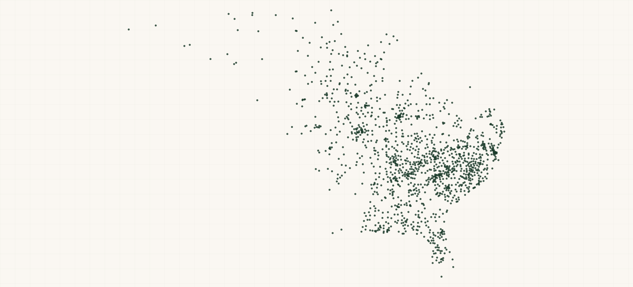
Hardee's, the Southeast- and Midwest-anchored QSR brand owned by CKE Restaurants (alongside its Western sibling Carl's Jr.), maintains a deliberately regional footprint of 1,479 U.S. locations that skews heavily toward rural counties and small metro areas — a distribution pattern almost inverse to McDonald's urban-suburban concentration.
More about this list
CKE's dual-brand geographic partition means Hardee's essentially operates as the eastern half of a national burger system, with virtually no overlap with Carl's Jr. west of the Rockies, making this dataset a clean proxy for CKE's eastern franchise network. The brand's franchise-heavy model (over 90% of units are franchisee-operated) creates a fragmented ownership landscape that is particularly valuable for food-service distributors mapping delivery routes, QSR franchise brokers identifying resale or multi-unit acquisition targets, and CPG field teams prioritizing DSD stops for breakfast-daypart products like biscuit mixes or premium coffee.
The file has all 1,479 locations across 31 states in one download. Building the same list by searching one area at a time tends to miss places, and a missed place looks like a gap in coverage that is not really there.
Need just some of them? Ask in your own words.
●Where the rows are
≡Sample Data Preview
There is no preview for this file yet. The free sample file has up to 10 rows.
{}What's in each row
| Field | What it is | Rows filled |
|---|---|---|
| name | Store name and number | 100% |
| address | Street address | 100% |
| city | City name | 100% |
| state | Two-letter state code | 100% |
| zip | 5-digit ZIP code | 100% |
| country | Country code (US) | 100% |
| phone | Store phone number | 100% |
| latitude | GPS latitude coordinate | 100% |
| longitude | GPS longitude coordinate | 100% |
| url | Url | 100% |
| geo_ | How exact the map point is: the source's own point, the street address, or the ZIP code's centre | 100% |
| county | County the location is in | 100% |
| county_ | Five-digit federal code of that county | 100% |
| address_ | Whether the street address is complete, missing a house number, or a PO box | 100% |
Rows filled is measured on every row of the delivered file.
✓Where this data comes from
This dataset is compiled from Hardee's's own public store locator, the system behind the “find a store” page on their website.
September 14, 2026
File built
15 fields
Columns in the file
Fill measured
On every row of the delivered file
How we build and date every file: methodology.
Using ChatGPT, Claude or an API?
No setup needed. Ask ChatGPT or Claude your question about the Hardee's Locations and give it this page: it can open https://locationlists.com/find?dataset=hardees-stores with the filters you need and show you the count and price.
Using ChatGPT or Claude? Tell it to answer from locationlists.com/find — no account, no connector.
How assistants ask
No connector needed. Any AI assistant can answer from this site with a web link, no connector, no account: open https://locationlists.com/find with the question as query parameters.
If a question needs filtering, distance, drive time, combining lists or a price, open a /find link: either put the question itself in q=, or build the structured link. The answer does not need an API, a connector or an account.
Simplest, the question itself: https://locationlists.com/find?q=<the question in plain words>
Or set the parts yourself: https://locationlists.com/find?dataset=<slug>&state=<ST>&city=<city>&county=<county>&zip=<zip>&near=<place or zip>&radius=<miles>&drive=<minutes>&where=<column>:<op>:<value>&total=<rows>
Leave out what the question does not need. Use radius for straight-line miles or drive for minutes of driving (5 to 60), not both; near can name several places separated by | to reach from any of them. To ask about several lists at once, use datasets with two or more names, or category with a kind of business. To compare two lists, add relate=nearest and the other list with b. in front of its parameters. To count by area, use areas=county (or zip, state, metro). To keep only places whose county, ZIP code, metro area or state meets a Census figure, add area_where (for example county:population>1000000); with areas, per=100000 gives counts per 100,000 residents.
Links an assistant can open, each showing how many rows match, a few preview rows and the price for just that part:
- The whole list: add a city, state, ZIP code or distance:
https://locationlists.com/find?dataset=hardees-stores
Optional: connect for repeat use or wallet payments:
Read https://locationlists.com/skill.md and follow the instructions to connect LocationLists. Then show me the Hardee's Locations list.Your assistant will walk you through setup and show you the price before you pay.
For developers
At 1,479 records this dataset is not sold by the row — buy the file. Without a connector, open https://locationlists.com/find?dataset=hardees-stores. An agent connected to https://locationlists.com/mcp can still search it, read a free sample file of up to 10 rows and buy the whole file itself. How agent purchasing works
?Frequently Asked Questions
How does Hardee's geographic footprint compare to Carl's Jr., and can I use this data to map CKE's total national coverage?
Hardee's 1,479 locations are concentrated east of the Mississippi — particularly in North Carolina, Virginia, Tennessee, and Alabama — while Carl's Jr.'s roughly 1,000 units cluster in California, Texas, and the Mountain West. Combined, CKE covers most of the continental U.S. with minimal brand overlap. If you need a merged CKE master file or an overlap analysis in border states like Oklahoma and Missouri where both brands coexist, LocationLists can build that as a custom deliverable.
I'm a broadline food-service distributor trying to optimize delivery routes to independent QSR operators in the Southeast. How useful is this dataset for that?
Extremely useful as a density anchor. Hardee's 1,479 locations — most of which sit on rural highways and in small towns under 50,000 population — form a skeleton map of where independent QSR traffic exists in the Southeast and Midwest. By plotting these alongside your existing stop list, you can identify clusters where adding nearby independent operators would reduce per-stop delivery cost. LocationLists can also run a proximity analysis against other QSR datasets in the catalog to quantify route overlap.
What does Hardee's rural skew mean for site-selection analysts evaluating competing QSR concepts?
Hardee's over-indexes in counties with populations below 25,000 — markets where it often serves as the primary branded breakfast option. This makes the dataset a useful negative-space tool: if you're siting a new Bojangles' or Zaxby's, Hardee's presence signals existing QSR demand in a small trade area, while its absence may indicate a market too thin to support a drive-through concept. The latitude/longitude fields in this dataset allow direct import into GIS platforms like Esri or Placer.ai for trade-area scoring.
I'm a franchise broker looking for multi-unit Hardee's operators who might be acquisition targets. Does this data help identify multi-unit clusters?
The dataset includes each unit's unique store ID (visible in the name field, e.g., 'Hardee's 1505548'), which you can cross-reference against state franchise disclosure records to group locations by franchisee. Clusters of 5–15 units within a single DMA often signal a mid-size operator — the sweet spot for roll-up acquisition. If you need us to enrich the file with estimated franchisee groupings or DMA-level unit counts, that's a custom project we handle regularly.
How does Hardee's location density compare to other QSR breakfast competitors like Waffle House or Bojangles'?
Hardee's 1,479 units give it roughly 75% of Waffle House's footprint and about double Bojangles' unit count, but with a wider geographic spread across the Midwest that neither competitor matches. The strategic insight is that Hardee's is the only national-scale biscuit-breakfast QSR brand with meaningful presence in states like Illinois, Indiana, and Missouri — markets where Waffle House and Bojangles' have little to no penetration. LocationLists can produce a custom overlap report between any two of these brands at the ZIP or county level.
Can I use this dataset to analyze Hardee's proximity to major retail traffic generators like Walmart or Dollar General?
Yes — combining this dataset with a Walmart or Dollar General location file lets you measure co-location patterns that reveal Hardee's site-selection logic. Historically, Hardee's franchisees have favored highway-adjacent pads near big-box anchors in rural markets. The geo-coordinates in this file support distance-matrix calculations in any GIS tool, and LocationLists can run a pre-built proximity analysis that flags every Hardee's within a specified radius of your chosen retail brand.